Category: Landscape Photography
Post Type:
Photography
Mixed Media: None | Cropped.
Pays
one point
and 2 member cents.


© Copyright 2024. ChuckWaxman All rights reserved. Registered copyright with FanArtReview.
ChuckWaxman has granted FanStory.com, its affiliates and its syndicates non-exclusive rights to display this work.
Posted: November 8, 2021
      |
Way Up High
Mt Shasta
by ChuckWaxman
Interested in this? Contact The Artist
Landscape Photography Contest Entry
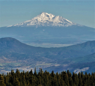
This picture of Mt. Shasta was taken from Mt Ashland in Oregon back in May.
Mt Shasta is a potentially active volcano at the southern end of the Cascade Range in Siskiyou County California. At an elevation of 14,179 feet (4321.8 meters), it is the second-highest peak in the Cascades and the fifth-highest in the state. Mount Shasta has an estimated volume of 85 cubic miles (350 cubic kilometers), which makes it the most voluminous stratovolcano in the Cascade Volcanic Arc. The mountain and surrounding area are part of the Shasta-Trinity National Forest.
Enjoy the view.
by ChuckWaxman Interested in this? Contact The Artist
Mt Shasta is a potentially active volcano at the southern end of the Cascade Range in Siskiyou County California. At an elevation of 14,179 feet (4321.8 meters), it is the second-highest peak in the Cascades and the fifth-highest in the state. Mount Shasta has an estimated volume of 85 cubic miles (350 cubic kilometers), which makes it the most voluminous stratovolcano in the Cascade Volcanic Arc. The mountain and surrounding area are part of the Shasta-Trinity National Forest.
Enjoy the view.
Mixed Media: None | Cropped.
 Recognized |


Mt Shasta
by ChuckWaxman
You need to login or register to write reviews. It's quick! We only ask four questions to new members.
© Copyright 2024. ChuckWaxman All rights reserved. Registered copyright with FanArtReview.

ChuckWaxman has granted FanStory.com, its affiliates and its syndicates non-exclusive rights to display this work.
